Trail Walking Le Crotoy - saint firmin - Photo
 Bonsaicd
Bonsaicd

User

© OpenStreetMap contributors
Length
Length
6.7 km
Max alt
Max alt
11 m
Uphill gradient
Uphill gradient
26 m
Km-Effort
Km-Effort  
7.1 km
Min alt
Min alt
2 m
Downhill gradient
Downhill gradient
26 m
Boucle
Boucle
Yes
Creation date :
2021-08-27 17:51:53.167
Updated on :
2021-08-27 17:52:16.554

(0 Reviews)

Walking
Walking
1h36
Difficulty : Medium

Scan this QR Code to open this trail in the SityTrail application

FREE GPS app for hiking

Logo SityTrail SityTrail

IGN / Geographical institutes

Download SityTrail from the App Store Download SityTrail from Google Play

Logo SityTrail SityTrail World

The world is yours!

Download SityTrail from the App Store Download SityTrail from Google Play Download SityTrail on Huawei AppGallery

About

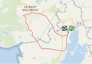
Trail Walking of 6.7 km to be discovered at Hauts-de-France, Somme, Le Crotoy. This trail is proposed by Bonsaicd.

Elevation profile

Positioning

Country:
France
Region :
Hauts-de-France
Department/Province :
Somme
Municipality :
Le Crotoy
Location:
Unknown
Start:(UTM)
402059 ; 5568611 (31U) N.

Comments

Please log in to post a review or rate the element


je viens de faire cette rando le chemin à droite à la sortie de le bout des crocs n'existe plus depuis de nombreuses années donc 2,5km en plus il faut prendre à droite vers la d'une, à droite après le pont de la mayeet ensuite à gauche vers St Firmin


Trails nearby

Trail Walking Le Crotoy - CDT80-3 - Photo
Walking

Walking

Medium
(2)
Le Crotoy, Hauts-de-France, Somme, France
6 km | 6.1 km-effort
1h 23min
Yes
Trail Walking Saint-Quentin-en-Tourmont - Les crocs - Saint Quentin en Tourmont - Photo
Walking
tracegps

Walking

Difficult
(4)
Saint-Quentin-en-Tourmont, Hauts-de-France, Somme, France
15.8 km | 16.9 km-effort
5h 30min
Yes
Trail Walking Favières - Circuit de Morlay - Photo
Walking
tracegps

Walking

Difficult
(1)
Favières, Hauts-de-France, Somme, France
12.4 km | 12.8 km-effort
4h 0min
Yes
Trail Cycle Rue - Rue-Ailly sur Somme par les chemins de Halage - Photo
Cycle
Baltykatt

Cycle

Medium
(2)
Rue, Hauts-de-France, Somme, France
75 km | 76 km-effort
4h 39min
No
Trail Equestrian Le Crotoy - de la Maye vers marquenterre - Photo
Equestrian
ioudina

Equestrian

Very easy
(4)
Le Crotoy, Hauts-de-France, Somme, France
20 km | 21 km-effort
2h 43min
No
Trail Cycle Le Crotoy - Crotoy - Marquenterre - Photo
Cycle
jacques.moulin@hotmail.com

Cycle

Medium
(1)
Le Crotoy, Hauts-de-France, Somme, France
18.3 km | 19.2 km-effort
1h 8min
Yes
Trail Walking Le Crotoy - traversée baie somme et train - Photo
Walking
lefrancm

Walking

Very easy
(1)
Le Crotoy, Hauts-de-France, Somme, France
24 km | 25 km-effort
6h 58min
No
Trail Walking Le Crotoy - La Maille - Pointe de St Quentin - Photo
Walking
tbrunet

Walking

Medium
Le Crotoy, Hauts-de-France, Somme, France
9 km | 9.1 km-effort
4h 30min
Yes
Trail On foot Le Crotoy - Balade au Crotoy - Photo
On foot
GUIDE+

On foot

Easy
Le Crotoy, Hauts-de-France, Somme, France
9.9 km | 10.4 km-effort
2h 22min
Yes


Close
My subscriptions